
Interstate 95 in Massachusetts
(I-95-MA)
- - States/Provinces
- - Overview Information
- - Map of Road
- / - Road Conditions
- EB..SB - Directional Listings
From Wikipedia, the free encyclopedia
Interstate 95 (I-95) is a part of the Interstate Highway System that parallels the East Coast of the United States from Miami, Florida in the south to Houlton, Maine, in the north. In the U.S. state of Massachusetts, it spans 91 miles (146 km) along a north–south axis. It is the third-longest Interstate Highway in Massachusetts, behind I-90 (the Massachusetts Turnpike) and I-495, while I-95 in full is the longest north–south Interstate, and sixth-longest Interstate Highway in the United States.
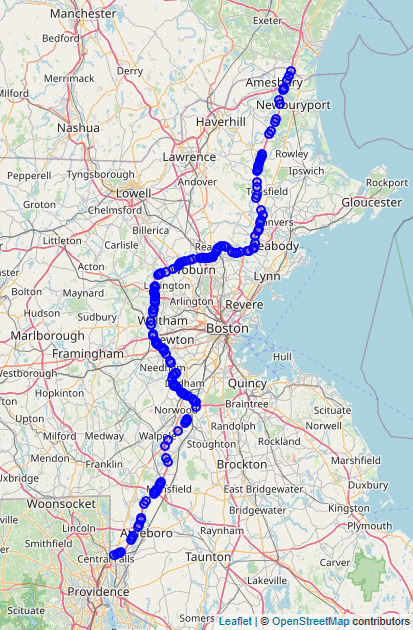
Its southern terminus within the state is located in Attleboro, where I-95 enters from Pawtucket, Rhode Island. It intersects with U.S. Route 1 (US 1) and the northern terminus of I-295 within Attleboro, I-495 in Mansfield, and US 1 in Sharon before arriving at an interchange with I-93, US 1, and Route 128 in Canton. At this interchange, I-95 begins running concurrently with US 1 and Route 128 along a beltway roughly 15 miles (24 km) outside of Boston. While earlier plans called for I-95 to run northeastward through Boston along the Southwest Corridor and a more northerly portion of Route 1 known as the Northeast Expressway, these plans were squashed due to fierce community opposition. As such, Boston is one of only two major east coast cities that I-95 bypasses (the other, Washington DC, for the same reason).
While its concurrency with US 1 ends in Dedham, its concurrency with Route 128 continues as it meets with expressways including the Massachusetts Turnpike in Weston, US 20 in Waltham, Route 2 in Lexington, US 3 in Burlington (with which it runs concurrently within the town), and I-93 and US 1 in Reading and Lynnfield, respectively. I-95 and Route 128 split in Peabody, as Route 128 travels north-east towards its northern terminus in Gloucester, I-95 continues north and crosses US 1 in Peabody and Danvers. Within Salisbury, it intersects the northern terminus of I-495 and arrives at its own northern terminus, where I-95 continues into Seabrook, New Hampshire as the Blue Star Turnpike.
Full Wikipedia Topic
| Route information | |
|---|---|
| Maintained by MassDOT | |
| Length | 91 mi (146 km) |
| Existed | 1957–present |
| Major junctions | |
|---|---|
| South end |
|
|
|
|
| North end |
|
| Locations | |
|---|---|
| Counties | Bristol, Norfolk, Middlesex, Essex |
Alpha Release News: see notes.